Saturday, April 04, 2026

Javanese Hills, Stone and Ash

 I

Civets are small nocturnal mammals, roughly the size of domestic cats, with a distinctive gut. Their gut hosts a “secret” bacteria that helps digest fruits uniquely – breaking down the entire outer pulp, and only permeating the inside seed with enzymes and gastric juices, reducing the seed’s acidity and bitterness while enhancing its aroma. When the fruit happens to be coffee cherries, and the wild animal has picked the ripest and the sweetest fruits from the forest for itself, about 24-hours of digestion in its gut will produce droppings of coffee seeds on the floor with a supposedly distinct aroma and sweetness. It’s sold as kopi luwak, one of the most expensive coffees in the world. Capitalism subsequently did what it does to exquisite products – leading to force-fed caged civets excreting beans that are commonplace in Indonesian airports and usually come with don’t-buy recommendations from travelers. I could find several boxes of ‘authentic’ kopi luwak each with different claims and price tags, and decided that I am doing just fine in life with my regular morning coffee.

Converting poop into coffee is a strange human endeavor, and the credit of its discovery goes to the human desire for accessing the forbidden. Coffee was introduced in the 19th century as a cash crop for plantations in Java and Sumatra by the Dutch, who controlled the Indonesian archipelago for roughly 350 years. Dutch plantation owners strictly forbade native workers from picking the cherries for their own use. Driven by curiosity and a desire for the “forbidden” drink, local farmers noticed that wild civets (luwaks) would eat the ripest coffee cherries but excrete the beans intact. They collected excreted beans, cleaned and brewed them. When the plantation owners tasted this significantly smoother and less bitter coffee, it soon became a highly prized, expensive delicacy among the elite.


II

Indonesia is a land tough to fathom. It’s the largest country in the world made entirely of islands – an archipelagic state. There are over 17,000 islands in Indonesia, with the largest ones being New Guinea (western half belongs to Indonesia), Borneo (shared with other countries), Sumatra, Sulawesi, and Java. The capital city of Jakarta is located in Java, the most densely populated island in the world. The number of people living in Jakarta metropolitan area is roughly the same as the entire population of Canada, or 1.5 times the entire population of Australia. It’s infamous for its traffic, though the city’s infrastructure has improved significantly with the country’s growth (Indonesia is one of the wealthier economies in Southeast Asia), and for me, commuting in elegant BYD cars amidst the imposing cityscapes feels like a privilege.

The term Jakarta evolves from ‘Jayakarta’, a 16th century name of the city. Jayakarta is a Sanskrit term (for victorious), bestowed on the city by Fatahillah, a Muslim military commander, who defeated a Hindu Sunda Kingdom. The lines between language, religion, conquests, and the modern state of Indonesia are challenging to understand from the perspective of clean lines drawn in the modern politics of India, the country I come from. But perhaps the modern lines are the strange ones. Hinduism and Islam in their older forms, on both sides of the Bay of Bengal, were less centralized, more local, and more porous than they are today. Both have narrowed into the national, textual, hyper-masculine versions we know now: small gods and local saints and Sufi dargahs giving way to a standardized faith convenient in politics. A Sanskrit name bestowed by a Muslim commander on a former Hindu capital belongs to a religious world that existed before this narrowing.

Jakarta Metropolitan Area
Jakarta Metropolitan Area (Image courtesy: Jakartadunia, CC BY-SA 4.0, via Wikimedia Commons)

The hotel I am staying at in Jakarta features two exquisitely woodcarved panels in the lobby, one portraying Ramayana stories in intricate detail, the other Mahabharata scenes replete with chariot battles and the moment when the Bhagavad Gita is delivered on the battlefield. Just these two panels carry a Hindu visual culture that is refined and heightened, a religion that took deep root in this country and grew its own flavor. The epic stories from Hinduism remain famous in Indonesia, and are the bedrock of their traditional wayang puppetry. Juxtaposed against this imagery, in the same lobby, is a Ramadan Oasis, a beautiful decor with colorful fanous lanterns hanging over a wooden camel and desert hut, to welcome guests for iftar. The city is in its most reflective and spiritual phase in the final days of Ramadan when I arrive – Indonesia is also the country that hosts the largest Muslim population in the world. I stand for a long moment between the panels and the lanterns, working out where I am: Hindu epics carved in wood on the walls, an iftar oasis at the centre of the floor, and a country with the world’s largest Muslim population going about its evening. Amidst the fantastic hospitality of Southeast Asia, this juxtaposition seems effortless, however strange to me.

Hindu and Buddhist ideas came to Indonesia from Indian merchants, who shifted their focus from the West to the “lands of gold” in the east after the Roman Empire fell in the 5th and 6th centuries. On the map, the most direct sea route between India and China goes through the Strait of Malacca, the ultimate choke point for global trade (more strategic than Hormuz, with roughly a quarter of all globally traded goods passing through it). The strait has been controlled variously from the lands of Sumatra on its west, Malay Peninsula on its right, and Java in the south, and the riches passing through saw the rise and fall of kingdoms often more prosperous than those around the Mediterranean. The Srivijaya kingdom (7th-11th century) was one of the early ones to prosper out of Sumatra, and became a global center for Buddhist learning. Then came the Majapahit (13th-16th century) in East Java, a Hindu-Buddhist empire that unified much of the modern Indonesian archipelago for the first time. Islam spread through the archipelago over these same centuries, carried by traders from Gujarat and the Arab world, and Sultanates rose as the Majapahit declined. The Dutch arrived in the early 1600s and left only in 1945. The Sanskrit-based courtly cultures of the previous thousand years produced some of the greatest achievements of Indian thought outside India: Borobudur, the largest and most philosophically complex Buddhist structure in the world, and Prambanan, a Hindu complex with Ramayana reliefs that are more complete and better preserved than any found in India today. I got a chance to visit Borobudur, which attracts around 1.4 million visitors a year, with foreign tourists surprisingly making up only about a tenth of that.


III

Borobudur was built around a natural hill in Magelang and dates to 9th century. This was the period of Shailendra dynasty (Sanskrit meaning “King of the Mountain”) that ruled Java and is associated with a cultural renaissance in the region. To get to the temple, I fly into Yogyakarta (another Sanskrit-derived name from Ayodhya, Rama’s capital in the Ramayana, joined with karta, or “accomplished”). Yogyakarta is situated in the southern part of the island of Java, and technically the only royal city in Indonesia still ruled by a monarchy. It has a surprisingly beautiful airport, with hallways and gate areas decorated in intricate Batik Kawung motifs on the ceilings and walls. The corridors are an art gallery in themselves, and most of the interior structure has a wood or bamboo-texture, and terracotta-style tiles. Every gate is a Gapura, a welcoming symbol of the Hindu-Buddhist kingdoms. The city is the heart of Javanese fine arts and culture, and the origin of globally popular batik textiles. It’s also the centre of Indonesian education. The ‘university town’ feel of Yogyakarta is apparent as I drive north to Magelang: there are photo copy and printing shops, establishments for laptop repair, billboards advertising scholarships and even notary services, and several fast food joints. As the vehicle moves farther out towards Magelang, the landscape changes into lush green paddy fields, and winding roads through canopies of banana, palms, and teakwood. Java has incredibly rich, volcanic soil that allowed for massive rice production. This surplus food supported a much larger population than other islands, providing the “manpower” needed for the vast armies and monumental construction projects like Borobudur.

As we drive further north, the massive silhouette of Mount Merapi looms to the right. This is one of the world’s most active volcanoes, and is the “source” of the fertility – the ash from its frequent eruptions is why the paddy fields stay so impossibly green. The vehicle also crosses several wide, rocky riverbeds (like the Progo or Elo rivers) which are apparently “lahar” paths that form the channels for volcanic mudflows. Locals still manually collect sand and stones for construction from these rivers. About halfway between Yogyakarta and Magelang is the town of Muntilan where the roadside is lined with hundreds of small workshops. In them, craftsmen carve volcanic stone into statues, stupas, and pestles – a living link to the stonemasons who probably built Borobudur.

Mount Merapi: Indonesia’s Most Active Volcano (Image courtesy: Wikimedia Commons, CC BY-SA 3.0)

IV

I am staying at Manohara, the only accommodation located inside the Borobudur Temple complex. The Sanskrit word Manohara literally translates to “stealer of the heart”, and the accommodation perhaps is named after the story of Manohara, one of the most famous Buddhist tales. Stories in Buddhism are called Jataka tales (Sanskrit for “birth stories”) and they are legends detailing the previous lives of Siddhartha Gautama before he became the Buddha. The more of the Jataka tales I encounter (primarily in Southeast Asia), the more I start seeing how much geography and characters are shared across Buddhism and Hinduism, apparently two very different religions of the world. Buddhism did emerge within the same cultural landscape as early Hinduism and shares the same spiritual vocabulary. Place names like Panchala, Hastinapur, and Ayodhya are common across Buddhist and Hindu tales, and Sanskrit serves as the common substrate for culture.

That evening, I walk to the restaurant at the rear side of Manohara, and stop. Across the lawn, half-hidden by the late afternoon trees, sits the most beautiful stone structure I have ever seen: a dark, stepped pyramid sitting on its hill the way a mountain sits on the earth, absolutely there.

Borobudur Temple (Image courtesy: Heri nugroho, CC BY-SA 4.0, via Wikimedia Commons)

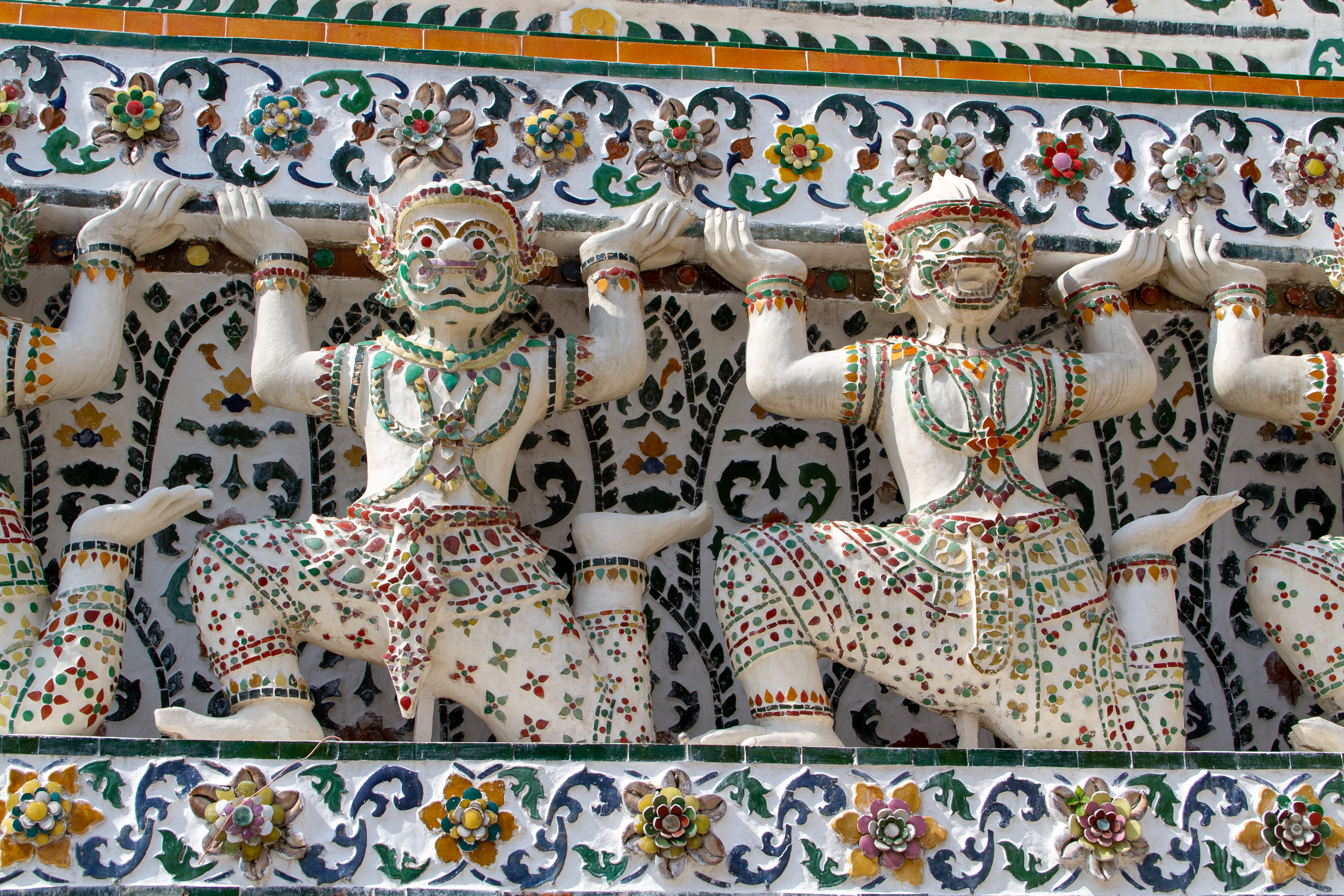
Borobudur temple is an imposing pyramidal structure built using almost 2 million blocks of gray volcanic stone. The square base of the temple can fit two full-sized soccer fields side-by-side with room to spare, and at 35m high, it rises to about 10 floors of a modern building. The structure is a massive Lego-like puzzle, with stones that were laid without a single drop of mortar and fitted together using intricate “knobs” and “dovetail” joints. The mortar-free masonry allows the entire structure to flex slightly during earthquakes, critical for a seismically active region like Java. When viewed from above, the entire structure is a mathematically precise Tantric Buddhist Mandala, representing a cosmic map of the universe. There are about 100 gargoyles, a sophisticated drainage system for tropical rains, each carved to look like a dragon. And that’s just the engineering.

My ascent begins at four in the morning. We are given thin sandals that feel like rubber, designed to softly tread the stones that have withstood the weight of prayers and hopes for centuries. A line of small flashlights threads up through the dark garden to the eastern stairway. A faint call to prayer drifts up from a village somewhere below, carried by the mist. We climb in silence.

As the first light reaches the corridors, the details become clearer, and immediately overwhelm the senses. The builders of the temple essentially “wrapped” a hill in stone and then carved it. The temple features over 2,600 relief panels narrating the life of the Buddha, his previous incarnations as the Jatakas, and the path of enlightenment, and 504 Buddha statues: a mind-boggling number of fine art installations that are essentially rock carvings done at the level of finesse and detailing of a wall painting. The monument consists of nine stacked platforms and a visitor walks through galleries making her way up to each. The walk up represents progressive realms of enlightenment. One starts at the lower realm, Kamadhatu, the realm of desire, depicting humans entangled in the cycle of samsara and the law of karma. The reliefs at this level show the consequences of human action in unflinching detail: gossip, theft, cruelty, lust, and the suffering each begets in the next life. Curiously, most of these panels are hidden, covered by a stone encasement added during construction, perhaps to stabilize the structure, perhaps because the imagery was considered too explicit. Only a small section at the southeast corner remains visible, a glimpse of the world the visitor is meant to be ascending out of. The second level is Rupadhatu, the realm of forms. To me, these five terraces are the most beautifully carved, symbolizing the stage where one has abandoned desires but is still bound by physical forms and names. These are narrow corridors lined with hundreds of relief panels and more than 400 Buddha statues in different mudras (hand gestures) housed in decorative niches. The reliefs here narrate the life of Siddhartha Gautama, his previous incarnations as the Jatakas, and the pilgrim Sudhana’s search for enlightenment. A visitor walking these corridors clockwise, as the temple intends, reads them like a turning book, each panel a chapter in the long argument that the Buddha himself was once like us. Then comes the top level, Arupadhatu, the realm of formlessness. These are circular platforms strikingly plain compared to the levels below. There are no narrative reliefs here, a detachment from the physical world. This level features 72 perforated bell-shaped stupas, each containing a seated Buddha statue. The visitor’s journey is clockwise to ascend each level, walking through nearly 5 kilometers of corridors, and symbolically spiraling upward from the everyday world toward the final state of Nirvana, represented by the empty, formless central stupa at the very peak. The architecture “thins out” as one reaches enlightenment.

Arupadhatu levels, Borobudur (Image courtesy: Gunkarta, CC BY-SA 3.0, via Wikimedia Commons)

I give up on clicking pictures of the panels, overwhelmed and saturated. It’s probably a hidden lesson about the nature of beauty. I start listening more intently to the guide. His hands, wrinkled and experienced, darkened by years of tropical sun, point at the clever stone joints, then to the history of the UNESCO restoration of the monument, and then to the stories of the largest panels, which he narrates with care. These are stories from my own childhood, common to Hinduism and Buddhism, that traveled from India to Java through conquests and rituals while communicating the same essence of life. It isn’t lost on me that my guide is a Muslim, who takes pride in this monument and its beautiful stories etched in stone over a thousand years. I chat with him more, and get to know his life story: his Umrah of 2015 to another great site in the world, and where he hopes to return for Haj in 2027 if he manages to save enough money. “I want to die happily,” he says. “Most people want to live happily. For me, this life is only a process. To get to the next one.” I marvel at the core of every religion that gives hope and meaning to human life, and simultaneously serves as a tool for political organization.

I sit near one of the “open Buddha” statues, one of the few open ones among the 72 enclosed statues at the top level where the outer stupas were damaged over centuries. This is the Buddha turning the wheel of Dharma. I look out at the horizons. Mount Merapi is visible, with its fiery interiors that have periodically deposited layers of volcanic ash and debris on this island over the years. A little to the right is the silhouette of the Menoreh Hills, its jagged ridgeline resembling a reclining person, who, according to a local myth, is Gunadharma, the architect of Borobudur who laid down to rest after finishing the massive task of building the temple.

I feel my breath in the early misty island air, and an unbearable lightness settles in my soul. My physical body is surrounded by nothing but stones built to enclose an emptiness. The place feels like a void, not of the melancholic type, but one that dissolves everything into it, marking everything that constitutes consciousness as irrelevant. There is no pride, privilege, ambition, or want in this space and time. I am far from Nirvana, but in these fleeting moments of almost meditative trance, I carefully note the last remnants of the physical world that appear in my mind. And I later reflect that these remnants were only the simplest things of absolute beauty: the sun rising behind the slopes of Merapi, its golden glow across the stupas, the fog in the valley below, birds waking up and darting through the sky, and a smile on my face that didn’t signify anything other than ‘being’.

It’s time to descend. I walk down in silence through the same platforms in reverse, the realms of formlessness, form, and desire arriving in sequence as the sun gathers strength. Halfway down I look back at the central stupa, smaller now from below, an empty bell against a clearing sky. The architects had thought of this view too. The descent is part of the design. You return to the world of desire knowing what is at the top, and what is at the top is nothing.


Monday, February 16, 2026

Fiji

I

Sugar. Yes please.” (Song by Maroon 5 in their 2014 album “V”)

Sugarcane is one of the thirstiest and most demanding agricultural crops on earth. It needs a warm, tropical climate, plentiful rainfall, and extensive human labor. To plant the crop, a worker will lay sections of stalk directly into the soil and cover them by hand (sugarcane is grown this way rather than from seeds). Once the crop grows to roughly 6 to 13 feet over the course of about a year, the worker will set the fields on fire to burn away dry leaves and debris, and to chase out snakes. The worker will then use long machete-like blades to cut individual stalks at the base, as close to the ground as possible, because sucrose concentration is highest in the lower portions of the stalk and diminishes toward the top. The leafy tops will also be cut off and discarded or left as mulch. Hacking away at the stalks, one by one, a worker might cut several tons of cane in a single day. The thick, dense lower stalks, thus harvested, will be sent to a sugar mill for extraction and crystallization. It is an arduous process defined by heat, smoke, and relentless physical repetition.

The history of the crop is as brutal as its agricultural production. Sugarcane originated thousands of years ago in what is now Papua New Guinea and the broader New Guinea region, where people chewed wild cane stalks for their sweetness long before anyone thought to refine them into crystals. From there, the plant spread to the Pacific islands, Southeast Asia, and ultimately to India. By the Gupta period, around 350 AD, Indians had developed and perfected the technique for boiling and refining sugarcane juice into solid crystals, which they called sharkara – the root of the modern word “sugar.” This knowledge spread westward through Persia and into the Arab world, coinciding with the transfer of the Indian knowledge of mathematics (and zero). Arabs subsequently brought sugarcane cultivation across North Africa and into Spain and Sicily during the medieval period. For several centuries, sugar remained a rare and expensive luxury across most of Europe, where people relied heavily on honey, dried fruits, figs, dates, currants, and berries for everyday sweetness.

History is replete with winners, losers, and turning of the tables. In the late 1870s, descendants of the inventors of sharkara were picked up by the British from the fertile plains of Uttar Pradesh and Bihar in India, and shipped off as “indentured” laborers to work the cane fields of Fiji, a Pacific island thousands of miles away from home. These laborers were known as Girmityas; Girmit being a distortion of the word “agreement,” a five-year contract signed by the British, often extended to ten or more years through debt, coercion, and manipulation. The arrangement uprooted families and saw a heavy death toll just from the voyage across the sea that took months in packed vessels. On the island, the workers were assigned to plantations, and made to work from dawn to dusk under the tropical sun, hacking away cane, to meet their quotas or face beatings. Women were doubly exploited with their bodies and their labor. In British parlance, this indentured system of formal contracts was a “humane alternative” to African slavery, which had been abolished in the empire in 1833.

Forced labor fueled the consumption patterns of the metropole, and the comforts of many empires were built upon the broken backs of millions. The Girmityas of Fiji never went back. They couldn’t afford the passage, or they had children born in Fiji who knew no other home. Sugar drove slavery elsewhere too. The Portuguese and Spanish had established cane plantations in Madeira, the Canary Islands, Brazil, and the Caribbean, building a mass sugar economy using enslaved African labor. The Caribbean became synonymous with sugar production, and the crop drove an enormous share of the Atlantic slave trade. By the 18th century, sugar had become affordable enough in Europe to sweeten everyday tea and coffee.

The indentured system in Fiji formally ended in 1916. The descendants of the Girmityas, the Indo-Fijians, constitute roughly a third of Fiji’s population, down from nearly half in the mid-20th century. Emigration and ethnic tensions after two coups have steadily reduced their numbers. Fiji still produces sugar, though the industry has declined significantly. The cane fields remain, sprawling across the western lowlands, reminders of the warp and weft of history.


II

The journey westward from Los Angeles to Nadi, Fiji’s gateway for tourists, takes about 12 hours. Somewhere above the vastness of the Pacific, the plane crosses the international date line, a human invention sketched arbitrarily across the expanse of the ocean. In an instant, hours vanish or reappear based on the direction of travel. The descent into Nadi begins over an endless blue with strange patterns composed of atolls, reefs, and islands emerging from the water. The turbofans slow down, the wheels extend, and the plane drops through layers of humid air before its tires meet the tarmac with a jolt and a screech. The landscape outside the windows is a riot of green. This is Viti Levu, the largest of the 800+ islands and islets that constitute the Fiji archipelago. Most are uninhabited. Some are barely more than coral outcroppings. But together they form a nation scattered across an area of ocean larger than many countries.

The first impression stepping off the plane is that of any quintessential coastal town. The air is thick, warm, and distinctly smells of the sea: laden with salt, humidity, and vegetation. I think human brains have a strange archival and recall mechanism – a smell, a tune, or a scenery can trigger vivid involuntary recalls of past experiences. For me, the smell of Nadi airport and the particular combination of heat, humidity, and sea brine transport me to Kerala, to a specific establishment called Kadavu in a town I once spent time in as a student. The connection makes no logical sense, but the olfactory memory is powerful and immediate.

The drive from the airport into town passes through lush fields of sugarcane, palm groves, and patches of forest. It is the rainy summer season this time of year, and the earth is soaked in yellow ochre mud and verdant green. Scattered along the roadside are homes made of concrete, corrugated metal, or thatched wood. There are small shops with brightly painted signs. A temple appears, its gopuram rising incongruously, a piece of South India transplanted halfway across the world.

Nadi is located on the western side of Viti Levu, in the heart of what was once the sugar belt and where Indo-Fijians are most concentrated. The city is a curious place, neither fully Fijian nor fully Indian, but something in between. There are many temples, including the large Sri Siva Subramaniya temple, apparently the largest Hindu temple in the Southern Hemisphere. It’s a large structure built in Dravidian style, with towers painted in vibrant hues of red, yellow, and blue. My visit coincides with the festival of Thaipusam, and I get to witness the decoration, the commotion of devotees, and a piece of India.

Walking through Nadi’s streets, there is a strange sensation of familiarity mixed with alienation. The local clothing is recognizable: women in sarees and salwar kameez, men in plain shirts and trousers, and the colors distinctly reminiscent of small-town north India. Names of shops are familiar – Shriji, Meenoo’s, Makanjee’s – and collections and displays familiar. And yet, the context seems wrong. There is the tropical heat, the trees are different, and occasionally there is an Indigenous Fijian face. This is not India, but its echo – a place shaped by India but fundamentally transformed by distance and history. The language is “Fiji Baat,” a creole evolved from the dialects brought by the Girmityas. It is rooted in Bhojpuri and rural vernaculars of eastern Uttar Pradesh and Bihar, but reshaped by over a century of isolation from the subcontinent. I can understand it, mostly, but it requires effort. The vocabulary is familiar, the grammar recognizable, but the rhythm is different. The intonation, the stress patterns, and the way sentences rise and fall all deviate from what I know. Some words are pronounced in slightly different ways, and the pauses fall in unexpected places. It’s a reminder of the beauty of languages and how they evolve, adapting to the environment and shaped by the confluence of cultures. Fiji Baat is a living link to the past, to the laborers who stepped off the ships more than a century ago. They brought only their dialects, their gods, and maybe hope. Language and faith are portable, and both have survived, adapted, and taken root in this foreign soil. India itself doesn’t appear to exist in the imagination of the local Indo-Fijian community, and the only connection is perhaps by lineage and ritual.

Nadi’s main street is a modest affair, a single road lined with low-rise buildings housing shops, pharmacies, travel agencies, and small eateries. I didn’t see any colonial quarters here, nor any carefully preserved historic district. Perhaps the town was never meant to be a showcase, and was just a service town for the sugar industry. There is a quiet commerce, with shopkeepers sitting in doorways, and shops with displays of cheap clothing on mannequins, knock-off sandals, and sunglasses. Obscure Bollywood music of the '80s and '90s, of the type that might be heard in Indian villages, spills out from crude speakers placed at the entryways of larger establishments. I walk the length of the main street in perhaps 20 minutes. It is not a place designed for strolling; the heat discourages aimless wandering. There are few tourists here; they tend to stay in the resort areas along the coast. Nadi doesn’t give the impression of an exotic paradise from tourism brochures. It is strikingly ordinary; a modest and unassuming working town that does not perform for the tourist gaze. It’s not interested in being picturesque, and it simply is – powerful in its lack of pretense. At least for me, there is also a pervasive sense of melancholy, as if the displacement never fully healed.


III

There is sea all around, achingly beautiful and utterly indifferent. It is the provider of fish and livelihood, the highway connecting the islands, and the source of myths, folklore, and life itself. Capitalism worked its magic and led to the development of Denarau, a purpose-built enclave on reclaimed land, home to marquee resorts and conveniently disconnected from the quotidian humdrum of Nadi town. Port Denarau is a picturesque marina lined with luxury cruisers, catamarans, and charter boats that ferry tourists out into the blue-green waters, generating significant employment and livelihood for locals in the process. There is a cheerful, slightly manufactured atmosphere here: drinks flow freely, Western music accompanies the sunset, and the mood is resolutely holiday. Every morning, day tours depart from Port Denarau, heading west to the Mamanuca Islands, a scattered chain of atolls and islets. Along the way are sand bars, crescents of white sand rising improbably from the middle of the ocean, sometimes just a few meters wide, surrounded by shallow turquoise water perfect for snorkeling. There is Castaway Island, made famous by the Tom Hanks film, and several other islands with resorts that have manicured the wilder edges, turning paradise into product, carefully packaged and priced.

Mamanuca Islands (Image courtesy: Tourism Fiji)

From my privileged vantage point at a fine-dining table at a Denarau resort, I see the white sand and hear the sound of waves breaking at a distance. The sun descends toward the horizon, and the sky moves through shades of orange and pink. The menu offers a delectable “farmer’s thali,” an Indian assortment that has undergone the same transformation as the language of Indo-Fijians. The ingredients are recognizable: dal, sabzi, roti, rice. The spices are familiar. But there is something distinctly foreign about the food: the proportions adjusted, the flavors recalibrated for this place. It is Indian food that has evolved beyond India, and does not project the hubris of India’s modern-day nationalism. It belongs entirely to the people who brought their culinary traditions to this remote archipelago and eventually made it their home. On the table sits a small bowl of sugar sachets. The irony is sharp and inescapable. This pack of crystals carries within it the weight of centuries: the labor that extracted it, the empires that profited from it, the lives it consumed and reshaped. It is simultaneously a symbol of exploitation and of survival, of brutality and of the stubborn persistence of communities that endured.

I think of the Polynesian and Micronesian navigators of the Pacific Islands centuries ago, who perfected inter-island travel on canoes, traveling between islands separated by vast stretches of empty ocean, navigating without instruments or maps. They read the stars, the shape and rhythm of ocean swells, the nature of wind, the flight patterns of seabirds, the color and temperature and smell of the water, the presence of certain fish, the way clouds gathered over distant islands, and everything that the sea below and the sky above offered. They were the original astrologers, with a now-lost knowledge system of extraordinary sophistication, developed over millennia, encoded in chants and passed orally.

The system used by these navigators was called “etak,” which is an inversion of perspective and perhaps a useful metaphor for life. Instead of imagining the canoe moving across a static ocean toward a fixed island, they envisioned the canoe as stationary and believed that the “island comes to you.”


Friday, February 13, 2026

Lessons in Transit


Fiji (Image courtesy: Viator)

The evening light is soft and golden, deceivingly so. It’s the middle of summer in Nadi, just a few hundred miles from the Tropic of Capricorn, and the tropical sun was blazing overhead just a few hours earlier. My luggage is loaded into the van that will take me to the airport, and sitting on the front seat beside the driver is the default setting in this part of the world.

“So, are you from Nadi?” I ask the driver.

“No, I am from the north of Fiji. Where are you from?” he replies.

“Washington DC.”

“Were you born there?”

“No, no. I moved there about 5 years ago. I was born in India. I only work in Washington DC.”

He nods and changes the FM channel. “You must be understanding this,” he offers with a smile.

“Oh yes, the previous one was a Bollywood song. This one seems to be a talk show.”

“Are they talking about love and romance?” he asks.

“No, it’s more like a discussion on skills needed to join the radio industry.”

“You know, there are many Indians here in Fiji.”

“Yes, Indo-Fijians, right? And they have a language that I can understand, but it’s slightly different.”

“They have been here for many generations. Most of them also speak Fijian, very fluently! You understand their language thoda thoda?” he asks, smiling.

“Oh yes, I can understand it. It’s just evolved slightly.”

After a momentary pause, he asks another question: “Is India very different from America?”

“Yes, very different. Washington DC has better infrastructure, I think.”

“Yeah, more advanced, no? What kind of work do you do?”

“I work with the World Bank. Its business is to give loans to governments, you know. For development work, like electricity, roads, schools.”

“Like here in Fiji?”

“Yes, Fiji. We have many projects here. Also nearby. Tonga, Tuvalu, Samoa, Vanuatu.”

“Wow. And you must have family back in India…”

“Yes, my parents live in India.”

“Hmm. I live here with my family. A wife, three kids,” he says with quiet pride.

“Nice. Boys and girls?”

“Two boys, one girl. My wife is studying. And I am supporting her.” He smiles. “One year done, two more to go. I struggle struggle struggle, for one year. After two more years, payoff!”

“Very nice. What is she studying?”

“She will be a teacher. You studied in India?”

“Yes. Education is good in India.”

“We have many doctors from India. And many patients go to India for treatment. So, India is definitely above us.”

“Well, India also has a lot of people.”

“Yes, that’s true. We have less than a million people.”

“And India has 1.3 billion.”

“Yeah. More people, more brains!” he observes.

“I don’t know if I would put it like that. But if you have so many people, even if some end up doing good, you get a sizeable number.”

“Yes, like you. You did good.”

“Haha. I don’t know if I really did good.”

“I am sure you did. So, Mr. Kumar. Give me some advice.”

“Tell me,” I offer sincerely.

“What should I buy? A car, or an island?” he asks.

“Depends on what you want to do. I think you are thinking about a career, which is going to be either your own business or a job where you will work for someone else. If you want to do something on your own, then between a car and an island, you would want to choose what will make more money for you. Is it going to be a car that you can use for a transport business, or an island that you can use for a tourism business. Whatever you think is better here in Fiji. But if you want to do a job, then you would instead want to think about who are the people or companies you would like to work for, what would they need, and what you need to learn to get there.”

“So, it’s about money?”

“I think it is. But not money for the sake of it. Money by itself is worthless. It’s a piece of paper. If you are alone on that island with a million dollars, you can’t eat your money. You would need food and water. I think you need to know what kind of life you want. Do you want to support your family? Have your kids get a good education? Travel around and see the world? Just have a nicer life? You need to know what you are aspiring for, and money is important to help you get there. I think money is about power. And access. It helps you navigate the world and is often the means to where you want to get to.”

“So you are saying that money is about purpose.”

“Yes. I am saying that money is important not because you just like to be rich, or because you are greedy. It is important because it helps you do what you want to do. But you need to know what kind of life you want. So, if you were to spend between a car and an island, you shouldn’t spend on the car because you just want to have fun driving a nice car. Then you buy something that’s not really making more money for you because that car will get old very quickly. You want to work hard, have honesty and intent, and put your money where it works for you.”

“Thank you, Mr. Kumar.”

“I don’t know if what I said made sense,” I add.

“You know, me and my wife have worked very hard. And after she completes her course, I have been telling her that we should move overseas.”

“Where would you go? New Zealand? Or Australia?”

“Australia. Life will be difficult there, no? My wife says it’s very expensive.”

“Well, it might be. But that’s what life is for. You work hard, it might not be as good as here, but then it gets better, because you have put in the work.”

“So you think I should move to Australia?”

“I definitely think you should. Look, nobody likes to move away from home. You think I really like being so far away, instead of being at home and eating my mother’s food? But that wouldn’t lead to the life I dream for myself. If you have a life that you dream of, you have to do difficult things, the hard things. Australia might be hard, harder than here. But you go through that, and then you achieve things.”

He grows quieter. And then I hear reflections: “you know Mr. Kumar, I drive this car. I take people to their destinations. People like you, coming from America. Others, coming from all over the world. I ask them for advice. And I learn. I record everything everyone says here.” He touches his temple. “I learn from different people who have seen different things. Today, I live in a rented house here in town. $350 a month. I drive this car with TTF, $5 an hour, 8 hours a day. But do you know I was a fisherman?”

“When?”

“I was a fisherman in my village. All I knew was how to fish. Using a spear. When people from my village see me drive this car, they say really, you drive this big a car? All they ever saw me driving was a small boat.”

“That’s a beautiful story,” I say, mostly out of words.

“I came to this town. It was difficult. In the village, we had fresh fruit, fresh fish. It’s not that easy here. When I came, I used to work 91 hours each week.”

“You were doing 13 hours a day?”

“13 to 14 hours. Sometimes 15. I used to drive a bus. Sleep in the bus anywhere on the side of the road. I worked as hard as I could. Now I am working for this company, sitting in this tourist car, in this uniform. I get to meet people like you. And I still work hard. Me and my wife support each other.” He sneezes. “See, that’s what happens to me with this aircon,” he grins.

“You know, I don’t know if you believe in God, but I think when you really work hard, and with honesty, God gives you the return.”

“Yes, you receive. When you work hard, you receive. And I have worked hard. You see, I had gotten so skinny when I used to drive the bus. Now look at me!” he says, pointing at himself.

“The universe indeed pays off. You inspire me.”

“Thank you, Mr. Kumar. My name is Bill, by the way.”

“You have a beautiful story, and you really inspired me, Bill.”

“Thank you, Mr. Kumar. And thank you for choosing TTF; I hope you had a pleasant ride. And as we say here, until next time. When you come back to Nadi, and if you choose TTF for transportation, ask for Bill.”

“I wish the very best to you and your family, Bill. And I hope you go to Australia!”

We hug, and he smiles warmly. “Bula Vinaka, Mr. Kumar.”


Saturday, October 25, 2025

From Shawmut to Boston, with love

The train rumbles underneath. It doesn’t shake my coffee cup, but it takes a moment for me to understand why the ground seems to stir beneath a café. I have just sat down for coffee in a shop with the quintessentially Boston tagline “Love, Always” after a walk along the Memorial Drive – a road built in the early 1900s along the Charles River. The river flows eastward, neatly dividing Boston and Cambridge, and emptying itself into the Boston Harbor. The city names are comparatively modern – if one ignores the American way of treating historic timelines – coined in the mid-1600s when English settlers started dotting the Atlantic coast of North America with colonies. Apparently, names such as Boston and Cambridge, borrowed from England, reflected the settlers’ “desire to recreate a moral and intellectual community modeled on their English roots,” perhaps because Shawmut, as the indigenous peoples called these marshy lands, wasn’t cutting it.

The city today seems to be living a maelstrom of cultural viewpoints. The apologies of its past ghosts have morphed into an over-compensating present, with a city intent on showing awareness of rights and justice in every corner of its streets. Its murals, ceremonies, and conversations seem to chase a morality that history never allowed, and the city almost performs conscience as a civic sport. Amidst this moral performance, its organic cafes, boutique shops, and ‘sustainable and community-driven’ ethos hint at a dreamy socialist utopia, set against the polished pavements and tree-lined promenades built from the spoils of colonial ambition and industrial might. At the same time, it is a city that provided finesse to capitalism – the engine of the modern world – through a culture steeped in innovation, research, and entrepreneurship, embodied by the venerable Harvard and MIT. And it is this version of the culture that enamors me, blending the city’s diverse historical and cultural viewpoints into one giant crucible of excellence.

My Memorial Drive walk takes me below the Longfellow Bridge, offering a view of the Boston ‘postcard skyline’ on the other side of the river. It’s a stretch of pavement that Richard Feynman and Noam Chomsky have shared as part of their daily routines, and I wonder if I belong here. There is bewilderment, as the mind juxtaposes the years of toiling-past with this momentous-present, as if they were from different lifetimes. Other emotions rear their head too, the ever-present imposter syndrome, a bit of anxiety about future, an immense feeling of missing a certain beloved, and some pride. After a meeting yesterday, Ashley and Michael showed me around the MIT Media Lab: here is the cancer research, here is the agentic web research, that’s where we sit. Here is the old building, designed with caverns underneath floors when they anticipated volumes of computer cables would run through them, and with small windows because they imagined engineers poring over screens in relative darkness to be the primary function of the building. Here is the new building, built as an extension to the old one, but with a different ethos – a well sunlit lobby, bright and modern interiors, for the age of wireless computing that arrived in less than a few decades. And here is a nugget: the old building was designed by I.M. Pei, the same architect who designed the Louvre Pyramid. Ashley decided to omit Pei’s alma mater Harvard in her kind discourse, but sportingly took my joke about Louvre’s recent heist. I thanked her for this first ever mini-tour inside an MIT building, a campus where I had driven a few times as a tourist. A mélange of emotions run their course through my head again, almost questioning – what am I doing here?


Longfellow Bridge (Image courtesy: Another Believer, CC BY-SA 4.0, via Wikimedia Commons)

The view from the Longfellow Bridge is iconic, and languid in these morning hours. Last weekend, the river hosted 60 years of Head of the Charles Regatta, the largest rowing race in the world. Today, a few teams rowing upstream feel like strays from the previous weekend. I turn right to walk alongside the Broad Canal, a small waterway dug up in the 1800s for barges to reach inland into Cambridge that was then an industrial zone with factories, mills, foundries, and warehouses. Today’s Kendall Square, “the most innovative square mile on earth” ecosystem of labs and startups, was a bustling manufacturing hub until the early 20th century.

From the coffee shop at the end of my walk, the city seems to be slowly waking up from its Saturday morning slumber. There is the periodic rumble of electric locomotives beneath the ground, keeping the city’s pulse alive. Brightly lit electric billboards along the road broadcast train schedules down to the minute, and public squares are punctuated with objects that feel almost scientific: a globe in a tiny plaza, a steel ‘molecule’ fashioned to hold bicycles. Faces pass by from the window: students carrying hopes for the future in their backpacks, academics who have seen generations of hope arrive and depart, workers and cleaners who keep the city’s lifeblood running. I myself have journeyed from streetside tea to oatmilk cortados, and contemplate whether I am a participant or merely a witness to this strange time and space.


Sunday, June 22, 2025

Chao Phraya Diaries: Layers of a City

In the Valmiki Ramayana, the great Hindu epic composed around 2500 years ago, there is an interesting apocryphal story. After the abduction of Sita, wife of Ayodhya’s (in India) king Ram, his ally Sugriva, king of the Vanaras (monkey race), dispatched his forces to search for her. His search parties went in all four directions with detailed descriptions of the lands they were to explore. The party headed east was told of islands and lands beyond the sea where the sun rises, apparently called Suvarnabhumi, the “Land of Gold.” 

While ancient texts refer to Suvarnabhumi as a place where traders acquired wealth, particularly gold, there is archaeological evidence that the riverbeds and streambeds of modern-day Thailand were indeed a source of alluvial gold, eroded from distant rock formations.

About a thousand years after the composition of Ramayana, around 500 AD, the Pallavas of Southern India (present day Tamil Nadu) started venturing eastwards via the sea for trade, and forged a deep connection with these lands of Southeast Asia. Their flourishing commerce of textiles, beads, semi-precious stones, and spices also exported Indian culture, religion (Hinduism and Buddhism), architectural styles (rock-cut temples), and scripts. The Cholas, who succeeded the Pallavas and dominated Southern India (~800-1300 AD), multiplied this maritime trade with Suvarnabhumi. It transformed Southeast Asia into a heartland of Hindu and Buddhist ideas – a legacy still visible today across Cambodia, Vietnam, Thailand, the Malay Peninsula, and Indonesia. The temples at Prambanan (Indonesia), Angkor Wat (Cambodia), and the vast Buddhist complex of Borobudur are remnants of this ‘golden’ period.

I have just landed at Suvarnabhumi International Airport in modern Bangkok, a bustling metropolis of 10 million people. Even on an early summer morning, the city feels hot, humid, and intense. There is movement everywhere, the roads are already choked, and a certain tropical smell pervades the air. Amidst this moment of rushed life, I think of the stillness of the city’s sacred spaces I have visited in the past, and the beauty of these opposing forces coexisting on the same landmass.

To truly understand Bangkok, it’s perhaps wise to begin with the topography. Thailand’s defining feature is the Chao Phraya River basin, covering almost one-third of the country’s land with verdant, fertile plain shaped by millennia of alluvial deposits. The Chao Phraya, or “River of Kings,” flows nearly 400 kilometers southward from the central plains to the Gulf of Thailand. Both ancient Ayutthaya and modern Bangkok lie downstream, strategically located just before the river reaches the sea.

Ayutthaya, located about 80 kilometers north of Bangkok, was a cosmopolitan capital around 1500 AD, serving as the center of an eponymous kingdom. Ayutthaya is an interesting natural ‘island’ at the confluence of three rivers (the Chao Phraya, Pasak, and Lop Buri), which provided a natural defense – a ‘moat’, before the term was claimed by capital markets. With Buddhism at its cultural core, Ayutthaya flourished through trade, drawing merchants from across Asia and Europe. It was here that the practice of digging canals (khlongs) began, to shorten trade routes by cutting across meanders in the river, making transport more efficient for merchants. Communities grew along these waterways, using them for transport, irrigation for rice fields, and daily life.


The ‘island’ of Ayutthaya (Image courtesy: Google Maps)

Ayutthaya fell to the Burmese in 1767, after which the deposed King Taksin established a new capital at Thonburi, a riverside village further downstream on the western bank of the Chao Phraya. This move laid the foundation for what would eventually become Bangkok. Thonburi was also the site of modern-day Wat Arun, which then stood as an older Buddhist temple (its present structure would be completed in the mid-1850s.) Taksin’s successor later moved the capital across the river to the eastern bank, establishing it at Rattanakosin, a site chosen for its natural partial enclosure by the river, much like Ayutthaya. The traditional practice of digging canals (khlongs) was used extensively, transforming Rattanakosin into an artificial island crisscrossed with both natural and man-made waterways, turning Bangkok into the “Venice of the East.” This was the Bangkok of late 1700s and mid-1800s, where people lived in stilt houses, commuted by boat, and shopped at floating markets. Remnants of that aquatic past still survive today – more for tourists than for trade – in places like Taling Chan Floating Market.

The banks of the Chao Phraya define modern Bangkok’s historic core: the Grand Palace, Wat Pho (Sleeping Buddha), and Wat Arun. This is the Bangkok of golden spires, monks in saffron robes, and ceremonial rhythm. Further east lies its modern commercial heart – Sathorn, Silom, and Sukhumvit – with glass towers, BTS Skytrain lines, and upscale cafes. Despite this crude description, Bangkok does not really have a ‘historic district’ or ‘old town’ tucked away for camera-toting tourists. Instead, it’s a sprawl of overlapping worlds: royal palaces and riverside temples, tangled street markets, sleek malls, roadside altars, canal-side communities, rooftop bars, and neighborhood life that hums in between like a colorful timelapse.


The banks of  Chao Phraya  and Bangkok's historic core: Wat Arun on the western bank, and Wat Pho and the Grand Palace on the 'island' of Rattanakosin on the eastern bank (Image courtesy: Google Maps)

As the city modernized, many canals were paved over for roads, rails, and buildings, shifting Bangkok from a water-centric layout to one dominated by land transport, along with its infamous traffic. Chao Phraya, however, remained a vital transport artery. A City Line ferry from Prannok to Sathorn offered me a charming passage through the heart of the city, and almost through time. Expert boatmen, who may have lived for generations by the river’s rhythm, dock and undock the boat effortlessly at five stops along my route, each feeling nothing longer than a metro stop. The water offers a good vantage point to see the spires of ancient temples rising along the water, followed by the gradual unfolding of modern skyscrapers as the boat moves further south. Being on a local boat suddenly takes away the rush of the city’s roads, and Bangkok’s past and present seem frozen in this skyline above water.

I visit Wat Arun on the western bank again, this time on a Saturday morning. The short ferry crossing from Tha Tien on the eastern bank of the river still feels like the best way to get there: the boat ride offers a phenomenal view of its distinctive 70-meter-high central prang (spire), slowly growing on one’s spirit. The whole temple complex is a curious amalgamation of Hindu and Buddhist symbolism. Primarily, it is a Buddhist temple, named after Arun, the Hindu sun god. The structure of the prang is a derivation of Buddhist pagodas but is topped by a trident, believed to belong to another Hindu god, Shiva, with the prang itself symbolizing Mount Meru of the Hindus. There are terraces that can be reached by a steep flight of stairs, dividing the structure into three symbolic levels in Buddhist iconography: the base indicating all realms of existence, the middle representing one of the seven heavens, and the top denoting the remaining six heavens. The decorations on the prang, made of colorful porcelain shards and sea snail shells, depict beautiful figurines of Yakshas (giants) and monkeys supporting it on all sides, along with prominent statues of the Hindu god Indra riding his elephant, Airavata. The temple once hosted the Emerald Buddha, the most sacred Thai icon, which was subsequently moved across the river to the Grand Palace. A hall next to the prang now houses the Niramitr Buddha. This intertwining of Hinduism and Buddhism makes me ponder upon the fluidity of religion: in the short run, it appears largely orthodox; in the long run, it survives through adaptation.

Wat Arun might also be the most photographed temple in Bangkok. Tourists flock to the “rent Thai costume” services, and nearly every photographer seems to take the mandatory shot of flowing fabric from a traditional garment worn by their subject, set against the backdrop of Wat Arun’s architecture. Local youth gather in equal numbers for wedding photoshoots, or to record TikTok reels in traditional clothing, churning the wheels of social media and the modern economy. Looking up from the base on the middle terrace, the traditional colors of Thai garments blend so seamlessly with the colorful porcelain of the spire walls and their figurines that my friend remarks, “this is a game of find-the-human.”


A close up of Yakshas on the decorated central prang of Wat Arun (Image courtesy: Shesmax, CC BY-SA 4.0, via Wikimedia Commons)

My destination during this visit on Rattanakosin Island, on the eastern bank, is Wat Pho, an old Buddhist temple complex a few meters south of the Grand Palace. While the temple predates the founding of Bangkok, it was rebuilt and expanded in the late 1700s and renamed as a homage to the most sacred site in Buddhism: Bodh Gaya (the common contraction of Bodhi Tree in Southeast Asia is Bo Tree which, in turn, inspires Pho). The complex houses a large collection of Buddha images, the most popular being the 46-meter-long reclining Buddha. This figure is said to represent the Buddha’s entry into Nirvana and the end of all reincarnations. The posture is called siha-saiyas, or “sleeping lion.” The soles of the Buddha’s feet are a distinctive feature, decorated with auspicious symbols made from mother-of-pearl. Narrow hallways encircle the reclining statue, with beautiful murals adorning the walls and ceiling. The building carries a mixed energy of devotion, awe, and modern tourism. Dropping coins in the 108 bronze bowls that line the corridor, representing the Buddha’s auspicious qualities, feels more like an act of vanity than of piety. Adjacent to the building housing the reclining Buddha is a small garden with a bodhi tree, apparently propagated from the Jaya Sri Maha Bodhi in Sri Lanka, itself said to descend from the original Bodhi Tree in India under which the Buddha attained enlightenment. Whether or not wisdom spreads, religious symbolism certainly does. Something I initially thought out of place, a Thai massage center within the complex, turned out, upon further reading, to be the Wat Pho Thai Traditional Medical and Massage School, one of the earliest massage institutions in Thailand. Its teachings are also inscribed on UNESCO’s Intangible Cultural Heritage list.


Feet with auspicious symbols of Buddha at Wat Pho (Image courtesy: Mastertongapollo, CC BY-SA 4.0, via Wikimedia Commons)

Outside the sacred spaces of stillness and away from the citys slick, modern façade, emerges the vibrant hustle of Bangkok’s streets – its narrow sois and hidden troks – where resides its authentic, pulsating heart. The sheer mass of humanity appears to be constantly in motion amidst an intimate, human-scale chaos, spilling horizontally across lanes that barely fit two, and vertically towards the skytrains and skywalks above. The sizzling woks, steaming bowls, and smoky grills are perennially on fire, with a constant slurping and chomping against the backdrop of intense smell hanging in the air – of meat, fish, vinegar, sauces, and often, incense. It’s remarkable that such a large number of humans in such small spaces rarely descends into a raucous cacophony. Instead, mutual respect subtly prevails, whether on foot or on motorbikes. Further out, on the citys main arterial roads, luxury cars and tourist buses often queue up neatly in stagnant lanes, while motorbikes, my preferred mode of transport in the perennially stuck traffic, zip past large vehicles as gracefully as water through a sieve.

Like most ancient cities, Bangkok has witnessed the rise and fall of rulers and followers, of souls who lived, breathed, and navigated the Chao Phraya and its canals, now long gone in the cycle of life. It’s also a city that is tirelessly reinventing, while holding on to its profound spiritual and cultural roots. Bangkok is a city that defines “stillness in motion.”


Sunday, May 04, 2025

In the Shade of Eternity: Sierra Nevada

“There was a Buffalo Soldier
In the heart of America
Stolen from Africa, brought to America
Fighting on arrival, fighting for survival”

A year before his death at age 36, Jamaican reggae icon Bob Marley recorded these lines about African American soldiers who fought in the “Indian Wars” of the 18th and 19th centuries. Depending on which narrative one reads, these wars may either be criticized as the westward expansion of the United States to seize Native lands and relocate tribes to reservations through the “Trail of Tears,” or praised as the pursuit of the “Manifest Destiny” of Americans to spread Christianity and democracy from the Atlantic to the Pacific oceans. The Buffalo Soldiers (arguably a pejorative) of the U.S. Army—African American regiments who “protected settlers” after the Civil War—were also, interestingly, deployed as the first park rangers in Sequoia and Yosemite National Parks before the creation of the National Park Service in 1916.

The Sierra Nevada (Spanish for “snowy mountains”) in eastern California is essentially a massive granite block roughly 640 km long and 100 km wide, that has been cut, shaped, carved and polished by glaciers and rivers since the Ice Ages. It hosts both Yosemite and Sequoia & Kings Canyon National Parks. Its numerous rivers are primarily fed by snowmelt, cascading into splendid waterfalls across its valleys, peaks, canyons, gorges, meadows, and lakes, making the Sierra a crucial “water tower” for California and neighboring regions. ‘Indian tribes’ (a phrase that always makes me cognitively dissonant as an Indian national) such as the Yokuts, Miwok, and Paiute have lived in this region for at least 1,500 years, until many were pushed off their lands during the California Gold Rush of the 1850s.

The Sierra Nevada range in California (Image courtesy: Dicklyon, CC BY-SA 4.0, via Wikimedia Commons)

Several ‘attractions’ and trailheads in today’s Sequoia National Park bear the name of one Hale Tharp, a Gold Rush miner who ventured into this area in the hope of making a fortune and settled into cattle ranching. His log cabin and barn are featured as the must-see “Cattle Cabin” in the park’s leaflets, while his dwelling made from a hollowed tree log, judiciously named “Tharp's Log,” is noted as a prominent contribution and a ‘historic site.’ Tharp also appears on information boards at various points in the park, including one at Moro Rock, a granite dome with a 2 km elevation, informing readers about the ‘explorer Tharp,’ who was the first person to ascend this prominent structure in 1861, ‘guided’ by two Indians.

History is written by the victors and is replete with narratives of their grace, legitimacy, and divine favor over so-called rebels and infidels. These labels shift, get rinsed, and are repeated every few hundred years. North Africans enslaved swathes of Christian Europeans across the Mediterranean; the Ottomans did the same with white Europeans from the Balkans; and the Crimeans went in the Russian hinterlands to capture white slaves. Europeans themselves did the same with Africans, turning it into the most profitable business of all. Religion, meanwhile, played a recurring role as the banner of legitimacy in these human pursuits of profit over the few hundred years of written history that we know.

And history is what reverberates as the theme across the enchanted landscape of Sierra Nevada.

“The Sentinel” is a majestic, 2,200-year-old giant sequoia in Sequoia National Park’s Giant Forest—the most famous and largest grove of these trees in the world. Sequoias are massive, routinely reaching 80–90 meters in height (comparable to a 25-story building), and grow slowly over centuries in ‘rings’ around the existing trunk. These rings archive history like etched grooves on a vinyl record. Each ring in the cross-section of a sequoia trunk, roughly representing a year of growth, can reveal wet and dry years, pest infestations, and occurrences of fire. John Muir, the naturalist credited with the birth of the U.S. National Park system, once described sequoias as “the greatest of living things.” Standing beneath a sequoia that has been alive for two to three millennia silently dwarfs you and your place in the world—physically and existentially.

The Sentinel (Image courtesy: m01229 from USA, CC BY-SA 2.0, via Wikimedia Commons)

The Sentinel began its life around 225 BCE, a time when much of Europe was tribal. Alexander’s vast, hard-won territory from Darius’s Persia had largely disintegrated. The Romans were expanding and consolidating power as a significant force on the Italian peninsula. Mauryan King Ashoka’s vast empire in the Indian peninsula had begun to fragment. The first unification of China under the Qin Dynasty was underway. And amidst all this, religion—the most profitable of human enterprises—had an entirely different fervor. The polytheistic Greeks, Romans, and Egyptians were worshipping a pantheon of gods and goddesses. Zoroastrianism was dominant in Persia, while Judaism was just past its early stages. Buddhism, having expanded significantly under Ashoka, was a major force in the East. Classical Hinduism was evolving from its Vedic roots, and the Bhagavad Gita was yet to be composed. The Mayan civilization was just beginning. Christianity and Islam did not yet exist. From its silent perch in a North American forest, unknown to the major powers of that Old World, The Sentinel was witnessing it all—quietly recording history while outliving empires. Standing before such an old tree, with its cinnamon-red bark storing all this history inside, makes you feel insignificant, yet strangely connected to the milieu of life beyond wars and conquests for temporary human dominance over nature. The sequoias’ silence hits you differently; despite their shallow roots and fire-dependent reproduction, they endure—in humbling contrast to human impermanence.

And further back in the arc of history, there are the rivers—the sculptors of Yosemite and Sequoia. Roaring through the canyons, they patiently chiseled the Sierra Nevada’s granite heart over millions of years. The entire range was born of molten magma that cooled and formed the soaring cliffs of Yosemite’s El Capitan and the gorges of the Kaweah. And the handiwork of these rivers resulted in the picturesque waterfalls and canyons we see today. Yosemite hosts the eponymous Yosemite Falls (the tallest in North America), Bridalveil Fall, and Vernal Fall, among many others—each framed by jagged granite cliffs, their mist swaying in the breeze and drenching onlookers. Sequoia features Grizzly Falls and Roaring River Falls, among others, cooling the air, their mist mingling with the scent of wildflowers. Despite the roar—much more pronounced in the spring when flows peak—these falls hold a quiet power, an intimacy with the rocks through which they plummet, thunder, and dissolve time. Occasionally, a double rainbow arches across the spray—a fleeting, timeless crown. In the deep, hardened soul of the granite, it is the rivers that have nurtured diverse ecosystems across the ages. A sign just outside Roaring River Falls reminds us of human fragility in this seemingly eternal world: Do not go near the rocks. People drown in this river every year.

Grizzly Falls in Kings Canyon (Image courtesy: Alexander Migl, CC BY-SA 4.0, via Wikimedia Commons)

Among granite peaks and ancient waters, the wildlife of the Sierra Nevada tells another tale of survival and loss through history. For more than two million years, grizzly bears were the lords of Yosemite and Sequoia, but were driven to extinction in California in less than a century by the traps and rifles of ‘settlers’ in the 19th century. Today, black bears still forage—often struggling futilely with modern bear-proof food storage boxes scattered throughout campgrounds and guest accommodations in the park. There are also mule deer, bighorn sheep, marmots, and even mountain lions and cougars—thankfully difficult to spot for entertainment’s sake in the park’s vast wilderness. Apparently, eleven woodpecker species inhabit this region, and watching one patiently at work on a tall oak tree was a delight.

To a modern-day visitor, Yosemite and Sequoia offer more than a thousand kilometers of marked hiking trails, a highway system with scenic vistas, campgrounds, and comfortable lodging options with reliable internet service—fruits of late-stage capitalism. It’s heartening to see how modern narratives in their visitor centers and information panels do at least partial justice to history, and how conservation programs strive to preserve the beauty and timelessness of this land that vastly predates—and will likely outlast—human stories.

Quoting Bob Marley again:

“If you know your history
Then you would know where you coming from”

On my way back from the Sierra Nevada, with sequoias’ shadows in my rearview, I thought a little about where I came from. And offered a silent prayer—grateful for the providence and amazing fortunes of my life.


Sunday, June 16, 2024

Masai Mara

The sun rises over the Mara.

The vast landscape gets bathed in yellow and appears to stir softly, like a gargantuan beast languidly waking up. The first thing one might notice at the break of dawn is perhaps the vastness of the land. The term “Mara” itself describes this landscape, or more accurately, how the Masai view it: Mara means “spotted” in Maa, the language of the Masai who dominated East Africa before European settlers arrived. Ecologically, the Mara is a tropical savanna consisting of large open grasslands with scattered trees and shrubs. To the uninitiated, it might be puzzling to comprehend that these ‘open’ lands offer the exceptionally rich biodiversity of mammals, birds, reptiles, and insects that the Mara is acclaimed for. But in Africa, appearances can be deceiving.

The sluggish mornings, at first, appear unaltered from one day to the next. The equator sun rises and sets almost at the same time each day, witnessing one of the only two seasons: dry and wet. The temperature follows the same pattern each day throughout the year. However, this apparent monotony disguises the countless warps and wefts of feeding, hunting, chasing, mating, nesting, communicating, and the enchanting twists of woes and fortunes that keep the Mara’s numerous inhabitants in perfect balance as authorized by nature. The previous night was not an uninterrupted slumber, and must have witnessed the pursuits and hunts of predators, the scavenging and patrolling of hyenas, the strolling and grazing of hippos, and the remarkable lives of birds and rodents. The ensuing day will not be mundane either, and will play out the drama of multiple cohabiting species asserting themselves within their relative pecking order in the food chain.

Masai Mara Landscape (Image courtesy: Byrdyak, CC-BY-SA-4.0, via Wikimedia Commons)

Masai Mara National Reserve in southwestern Kenya stretches over 1,510 square kilometers and forms a wedge-shaped landmass that is the northernmost section of the larger Mara-Serengeti ecosystem. The Serengeti side, ten times larger than the Masai Mara, is in Tanzania. Humans carved these borders, unbeknownst to over a million animals, including wildebeests, zebras, gazelles, and elands, that move along an ancient route from the southern Serengeti to the Masai Mara and back, searching for grazing and water: the Great Migration. It seems almost absurd that one species, humans, should find itself ‘wondering’ about the existence of such variety of life on the planet, as if humans themselves could have survived and thrived any other way.

Small 12-14 seater turboprop planes fly from the heart of Nairobi to more than a dozen airstrips in the Mara, instantly transporting one from an urban sprawl to Wild Africa. As a first-time visitor to this world, I flew into Keekorok, perhaps the most prominent airstrip serving the southern part of the Reserve, popular for wildlife viewing. The Cessna Grand Caravan’s raucous turbine engines glide the aircraft just about a kilometer above ground through its hourlong journey, offering a curious variety of scenery and interspersed clouds from its windows.

Taking off from Wilson Airport, an aerial view of urban Nairobi appears first. It reveals a neatly gentrified layout of green patches of large colonial mansions, commercial high-rises, and dense shanties, often separated by arterial roads: clean insurmountable straight lines dividing the haves and have-nots. A little further, there is a silhouette of Ngong Hills, popularized by the movie “Out of Africa,” followed by the Great Rift Valley and some lakes. The landscape turns green, with a patchwork of farms, fields, and forests. 

Mara River (Image courtesy: ryan harvey, CC-BY-SA-2.0, via Wikimedia Commons)

Next, the iconic savanna comes into sight, and one can distinctly see the Mara River and its tributaries that sustain the diverse habitats and wildlife and are central to the annual wildebeest migration. As the aircraft begins its descent, a tower of giraffes is visible below, casually browsing trees and shrubs. Finally, the plane’s rugged landing gear touches down on a rudimentary gravel airstrip and decelerates quickly to a halt. Touchdown on gravel feels quaint for a city-dweller like me who is used to asphalt. There are no built structures around this airstrip that might require taxiing, parking, or gates. One simply picks up their bag from the rear of the aircraft, walks out on the gravel, and finds themselves in The Shadow of the Sun.

About 100 feet from the airstrip, wistful Masais sit on the ground with assorted knickknacks and kitschy souvenirs spread hopefully in front of them. They bear the disproportionate burden of ‘saving the environment’ by cordoning off these lands exclusively for ‘conservation’. A burden perhaps imposed by those who invented capitalism, primitively demonstrated here through the act of selling knickknacks and souvenirs, often to the inventors themselves.

Keekorok Airstrip

To the left, there is a makeshift toilet, and on the right, a small ticket counter that seems permanently closed. A solitary wooden signboard with stenciled letters is the only marker of the place and its coordinates. Several Toyota Land Cruisers with their quintessential open tops wait in line to collect their respective patrons who descend from the aircraft, armed with backpacks containing sunscreens, insect repellants, wet wipes, water purification tablets, first-aid kits, sunglasses, binoculars, and everything else described on travel websites. Many have separate bags with protruding camera lenses. Amidst this inconsequential theater of human behavior, I spot my guide and companion for the journey into the Mara.

Kaiyoni is a young Masai man who prefers wearing his colorful Shúkà – the traditional red, blue, and black clothing paired with intricate beadwork jewelry – during mornings but switches to jeans and t-shirts otherwise. He is sharply built, with piercing eyes and perhaps an acute sense of hearing and smell. Over the course of my time with him, he would emerge as someone possessing almost a sixth sense, making him constantly aware of the whereabouts of wildlife in this vast reserve. He would also demonstrate his driving prowess, navigating a Land Cruiser through hills, marshes, swamps, high grass, and river streams. Accompanying him is Jacob Obongo, the manager of Enchoro Wildlife Camp, who has hired Kaiyoni for this booking. Kaiyoni speaks little English, and Jacob doubles up as an interpreter for our upcoming safari.

It’s amusing that the word ‘safari’ is Swahili, meaning journey. It originally referred to long-distance travel on trade routes between African and Arabic cultures, with the Arabic word ‘safar’ also describing a journey. European explorers introduced ‘safari’ into English to describe their big-game hunting expeditions into the African interior. In contrast, the rather unimaginative word ‘game’ is very much English. It derives from a root word meaning fun and amusement, and was used during the colonial era in Africa to describe hunted animals as “game animals” or simply “game.” This term is now entrenched in wildlife management and conservation, often appearing in official contexts such as “game reserves.” Modern safaris are associated with wildlife viewing and photographic expeditions rather than hunting. Most safari-goers now travel with the goal of seeing Africa’s ‘big five’: the lion, leopard, elephant, rhinoceros, and Cape buffalo.

Driving with Kaiyoni, my first thought is the sheer abundance of the Mara. Herds of gazelles, impalas, elands, and wildebeests are easily spotted. Dazzles of zebras and towers of giraffes can be frequently seen up close. A pod of hippopotamuses grunts and bellows in the water, keeping themselves away from crocodiles. Sounders of warthogs run with their erect tails, providing comical relief in this seemingly precarious setting for the human eye: appearances can be deceiving, and a predator is always on the prowl.

Gazelles in the Mara (Image courtesy: Paul Mannix, CC-BY-SA-2.0, via Wikimedia Commons)

Occasionally, I see flightless, 2-meter-high ostriches staring into the oblivion with their pink skins and black plumage, and stunning kingfishers perched on shrubs. At some point, I also see Cape buffaloes. Their massive bodies are covered in a thick layer of mud with an egret perched on their backs, picking off insects in a perfect symbiotic relationship.

In the afternoon, a coalition of cheetahs walks along the dirt road, probably looking for a place to rest and digest, undisturbed by the long lenses pointed at them. Kaiyoni’s sixth sense activates at some point, and he starts driving off the dirt road, into the grass, across the marshes, and around the trees for a few kilometers, until we arrive at a magnificent sight: two different prides of lions resting under the trees. It seems perfectly natural—an ironic use of the word—that a dozen lions with all their ferocity would be resting in this vast savanna. It feels almost obscene for humans to be there at all.

The next morning, we witness a lioness, patiently waiting, blending seamlessly into the golden savanna grass. Her amber eyes are fixed on a small herd of gazelles. At a chosen instant, she explodes into action, and the savanna erupts into a quotidian drama, majestic to human eyes. The gazelles scatter, their lithe bodies bouncing across the plains, safely into survival. The lioness and her cubs will have to wait for another hunt to feed themselves. Kaiyoni smiles, having seen this sequence unfold numerous times, perhaps understanding the sacredness of the ritual of feeding better than the rest of us. He then drives us to another hill far removed from the road, where we see a herd of elephants in the glorious morning sun. By now, we have been humbled into complete submission.

The African safari experience could be described as one of setting context to human existence. Driving for hours in the endless wilderness effectively chips away at the boundaries of human life and its self-centrism, revealing a world of flourishing beauty that neither needs nor wants humans. The intricate machinery of nature hums in perfect harmony here, from tall grasses and acacia trees nourishing wildebeests and zebras, to lions and leopards stalking these preys, and vultures and bacteria completing the cycle of life. This ever-shifting tapestry of life operates independently of human inventions, concepts, identities, and beliefs. Nature does not have democracy, as a friend remarked. The abstractness of humans and their inconsequence to this vast, rich ecosystem provides a context that is both bewildering and humbling. As I ponder my dreams, aspirations, skills, and enterprise, there is a feeling of liberation in noting the perverse fungibility of life and the fickleness of our feeble breaths. The Mara is an effective medicine to dissolve ego, allowing one to lose oneself and find it anew.